A team from the University of Tokyo has successfully used artificial intelligence to quickly detect and map over 200,000 rocks on the surfaces of two distant asteroids. The breakthrough, announced in the scientific journal Scientific Reports on Monday, marks a significant advancement in both space research and Earth-based applications like disaster prevention.
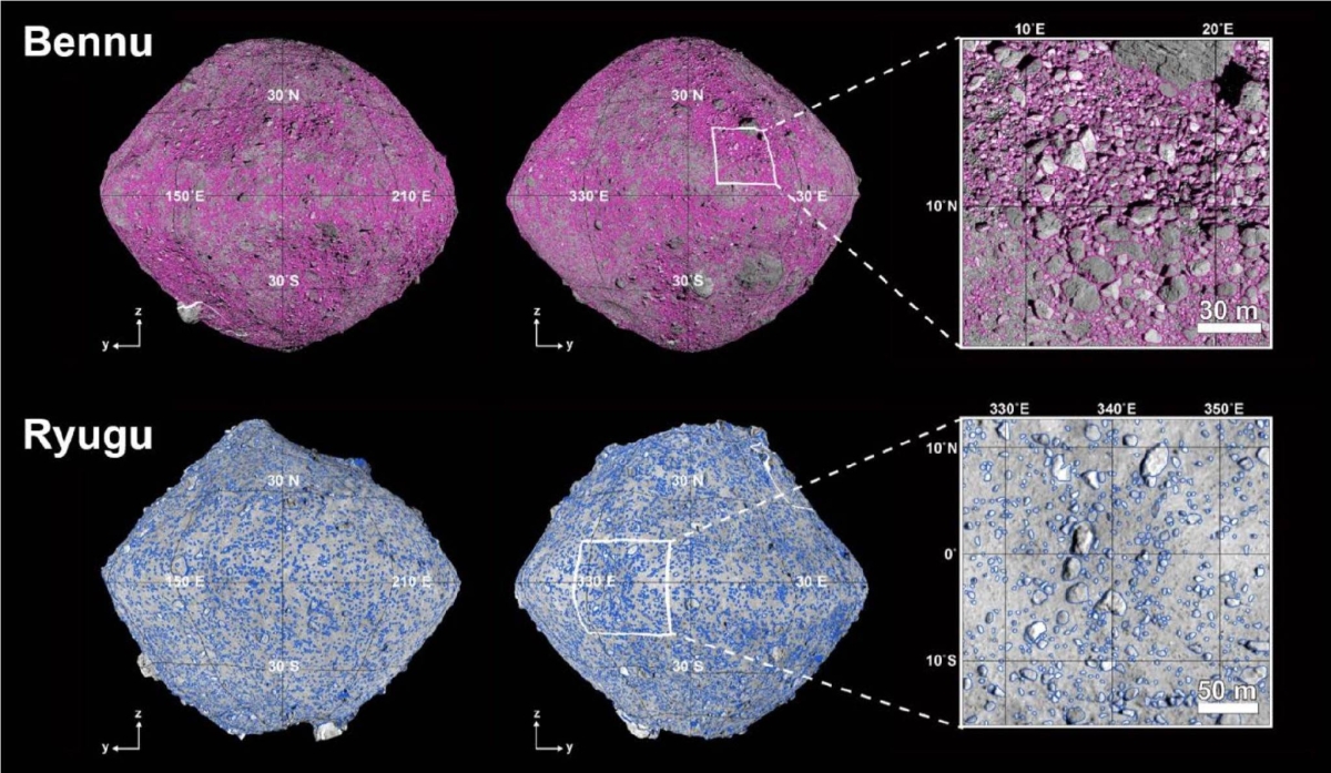
AI Analyzes Photos from Hayabusa2 and Osiris-Rex
Researchers analyzed photos taken by two unmanned spacecraft—Japan’s Hayabusa2 and the United States’ Osiris-Rex. Hayabusa2 captured images of asteroid Ryugu, while Osiris-Rex photographed asteroid Bennu.
The AI system, developed by the University of Tokyo, processed more than 10,000 high-resolution images. Within hours, it identified approximately 20,000 rocks on Ryugu and 180,000 rocks on Bennu, each measuring at least one meter in diameter.
How the AI Was Trained
To build the system, the team first fed data on 70,000 rocks from Earth and other celestial bodies into the AI. This allowed the system to “learn” how to identify rocks based on size, location, and shape.
The result? A powerful tool that can automatically scan and classify rock formations in a fraction of the time it would take a human. According to the team, the process takes only half a day per asteroid—a major improvement in speed and efficiency.
What the Findings Reveal About Asteroids
The research team, led by project researcher Yuta Shimizu and Professor Hideaki Miyamoto, also studied how rocks are spread across the asteroid surfaces.
Opposite Rock Flow Directions
On Ryugu, rock and soil appear to have flowed from the equator to the poles. In contrast, on Bennu, the flow pattern is from the poles to the equator.
This opposite direction is due to the differences in each asteroid’s rotation speed. Ryugu spins every 7.6 hours, while Bennu completes a rotation in 4.3 hours. These spinning speeds create different centrifugal forces, which in turn affect how material moves across each surface.
Earth-Based Applications: From Space to Slopes
The team’s discovery could do more than just advance space research. It also has potential real-world uses here on Earth.
“We expect that our research will also be used to detect signs of a rock collapse on Earth,” Shimizu explained. “Drones can fly over mountain slopes regularly, take pictures, and use our system to spot rock movement early.”
This could be a game-changer for civil engineering, landslide prevention, and natural disaster monitoring.
Future Missions and Expanding Use
The AI system will also be part of Japan’s upcoming Martian Moons Exploration (MMX) mission. This mission is scheduled to launch in fiscal 2026 and will target Phobos and Deimos, the two moons of Mars.
The University of Tokyo researchers are hopeful that this tool will continue to prove useful in future space missions and help keep people safe on Earth.
A Step Forward for AI and Planetary Science
This project showcases how AI can enhance scientific discovery by speeding up tasks that used to take weeks or months. It’s also a prime example of how space technology can benefit life on Earth.